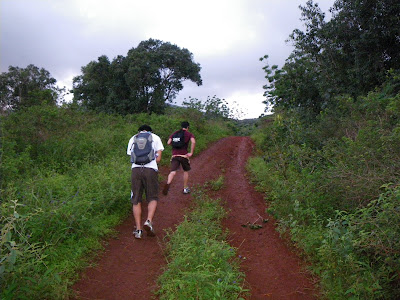
We walked along the 2 mile trail and kept looking back in case cars were coming, and as we looked back, it seemed like we hadn’t gone very far at all. To the left in the beginning was the school, then the Pioneer seed plant. After those, there was just cropland on both sides of us. Finally after about 15-20 minutes, we reached the gate to get onto the trail. There was a small house with a sign on it that said that the land we were on was Kamananui Ranch. The lights were on, and there was a Camry and a Dodge truck parked outside. We looked at the sign on the gate that said, “No Hiking Without Permission,” and we actually thought about going to the house and asking if we could go in. Then we thought, lots of others haven’t asked for permission so lets just do it. Besides, no one came out of the house as we approached the house or as we slipped through the gate. So through the gaps in the gate and up the 4x4 path… There was mud there too, and we got more caked onto our shoes until we just gave up trying to get the mud off. A little while in, we encountered some grazing horses that looked at us when we passed, then continued eating as if they knew who we were. Along the beginning of the trail, the horses are probably allowed to roam free, so there’s piles of poop everywhere. We didn’t mind if we stepped in the poop accidentally because the mud layer on our shoes just caused the poop to fall off eventually. We went through another gate later on, and a little while later, we had to hop a sort of redneck fence, which was two metal posts with fence wire connected to them, and for a gate, someone used two bungie cords. We laughed as we took the bungie cords off and replaced them after we walked through. The beginning hike up the 4x4 road takes you up about 1000 ft, and is pretty steep. We looked for the ribbons that marked the trail and followed those. However, many ribbons are placed in obvious places, and not the places that matter. An example of this comes up in this next part…
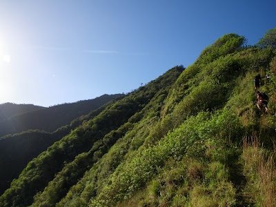
We finally made it past the mud and came on a part covered in the grass that has the teeth on it, so if you run any part of your body along the grass the wrong way, you’d cut yourself. Not a huge cut, more like a paper cut, but it was irritating. The grass was about shoulder high, and we felt like we were in a lord of the rings movie or something. There was no ribbon in sight along the grass part, so we just followed our instincts and tried to find a worn out path from the treading of previous hikers. After going down the mountain through the grass, we felt like we were going the wrong way until Mits found a ribbon. The trail now became clearer as less and less grass showed up. We were back to the dirt part, except that there were trees now, and ribbons everywhere. Kendall pointed out that whoever put the ribbons on was trying to be helpful but just didn’t place the ribbons in the most helpful parts of the hike. We didn’t get ridiculously lost on the trail, so we didn’t mind the placement of the ribbons. Also, we could usually find out where the trail led to next. More hiking up more dirt and tree covered hills… We hiked up some more until we came to a narrow part that had more rocks than dirt. The trail was turning into a mountain now, and we were out of the forest and mud. Mits, Jared, and Kendall ended up crawling that part, and it seemed like a good idea because there were huge drops. For some narrow parts, there was a drop on one side, and we got through that part easily. We came on a part with huge drops on both sides and went through that part pretty easily too. The view looking straight down was amazing and looking back at where we entered surprised us because we couldn’t believe we had hiked that far. So the hike seemed pretty easy and you’ll be fine as long as you’re in shape and aren’t afraid of heights. We came upon this 30 foot drop that was actually a lot easier to go up and down than it looked. We went one by one, in case the rope couldn’t hold, and were done with the part in no time. After the drop, we had to climb back up to continue on. The next part doesn’t have a rope, but the rocks are lava rock kine so you can just walk or crawl up. As we continued on, we ran into many more rope sections, too many to count. Some were slippery and some were manageable, but one rope section was challenging: you had to use the rope and put lots of your body weight on the rope to climb up a rock section that was wet, muddy, and had no definite places for good footing. You had to trust that the rope could hold your weight and not break as you climbed up the section. I don't usually rely heavily on ropes unless I need them because you never know when a rope will snap or break with all of your weight at the end. After the challenging part, the other rope sections were basically repetitive: you could use the ropes for going up, but they were mostly for helping you get down without tumbling down the mountain. Jared went up and down mostly using his hands and feet only. Crazy.
There are also blackberry bushes everywhere at your lower leg level. They had sharp thorns and were small, disguising themselves among the other plants on the mountain. You couldn’t really focus on looking for the thorny bushes while hiking up and going through a rope section. We ripped out lots of blackberry bushes on our way up so we wouldn’t have to go through them again while coming down. Finally out of the thorns and done with the ropes, we made it out to a clearing where there was an abandoned shack and radar. We stopped to get a look at the view and continued on, where we ran into stairs. The stairs led to another shack that was actually being maintained, because it had a new looking “high voltage” warning sign on it. Continuing on the stairs for a little more, we went on until we came to a bridge, and after crossing it, we found the end of the trail sign and a road. I read about the road; FAA people get to the FAA base at the top using the road and, as we saw from a sign, use by hikers is prohibited. Kendall was mad because we would have to hike the same path down, but it wouldn’t be the true Dupont trail hike if we cheated and took the road down, so the rest of us figured we had to return using the Dupont trail.
We followed the road up until we came to the FAA base. The huge golf ball radar was all that was visible until we got closer, and we could see the barbed wire all along the top of the fence as we got nearer. A woman in army camo came out of a building and went into another in the base as we approached. We went up a hill on the side and found that the gate was closed, and we didn’t wanna hop it because the FAA people might have gotten mad. So we sat on a concrete block outside of the base and ate some energy bars and had a snack break until the same woman came out and asked us if we were with DLNR. We told her that we hiked up on our own and she seemed surprised and told us that this hike is rated “treacherous,” so the DLNR only gives out maps to people who ask. We just wanted to do this hike and read about where and what to do without even knowing that, so we felt accomplished. We shared experiences and info, and she later asked if we got permission to hike. We told her straight out that we didn’t, and she didn’t seem to care and only said what a mother would say, that we were supposed to get permission, but didn’t get mad and said that many others also hopped the gate to the trail as well. She said that we could go around the base and walk along the fence if we wanted to, and she said to hop the fence that was locked. She would have let us in to look around, but they aren’t allowed to do that and we were fine with that. We could just scale the fence. She even gave us her phone number to give to other personnel if we got stopped while looking around so we wouldn’t get into trouble.
The wind was crazy up at the base. It wasn’t cold at all, but the wind chill made my hands numb. The FAA Lady was really nice; she offered us jackets and water, but we told her we were fine. We got to see nice views of across the island all the way to Diamond Head and views of Waianae. There were no clouds, and we got the view on a pretty good day because while there weren't clouds, there was vog, so we had a hard time seeing Diamond Head.
Coming down isn’t as bad as we thought it would be, because we were able to go through the rope sections quicker and easier than when we came up. Again, at the end, we slipped through the gate and made our way back to the entrance down a now sunlit and dry path. We thought we would be like those other people who took 12 hours or maybe more, and at the pace we took it, we finished in good time. We called the FAA Lady to thank her, but she didn’t answer and we couldn’t leave a voicemail, so we just left at about 2:30 and came back home to get Jared’s car. A long, but rewarding hike, the Dupont trail has its challenging parts but is mostly easy uphill hiking. It’s hard on your knees when coming down so take it easy. The highest point on O'ahu on Mount Ka'ala, according to GPS, is 4,081 feet above sea level. The distance going up is 5.1 miles so the roundtrip is about 14 miles including the first long dirt road. It took us about 4 hours to get up there, and after the nice views, we started our descent, back the way we came. We blazed through the trail and were down in about 3½ hours, totaling a 7½ hour hike.

Making our way to the entrance

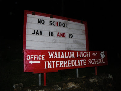
The school sign

This picture was taken in the morning but with a 4 second exposure, so it looks like daytime

What it really looked like going down that road in the morning

4 second exposure looking back

4 second exposure

read the fine print

an old ford tractor thing

up the 4x4 road...

long way to go...

panorama looking down


the grass section

out of the grass


panorama


The FAA station is far away

narrowing...

crawling...


high up

FAA in the distance

30 ft drop

Mits going down

on my way down

looking up from the bottom


looking back...

up, up, up...

radar. Jared took this

the bridge

the end

continuing along...

Who's down?
No comments:
Post a Comment